Villa de cura
Villa de Cura and, sometimes, simply known as La Villa, is a capital city of the Venezuelan city of Zamora in the state of Aragua, it has been the capital of the states of Guárico, Aragua and Guzmán Blanco (now extinct). The main economic activities are saddlery, agriculture, commerce and pottery.Geography
Villa de Cura has an area of 448 km2 and is located at an altitude of 526 meters above sea level, measured in the main church, while its altitude is 521.71 meters above sea level from Plaza Bolivar. It is located in a valley between the currently dry rivers: the Curita River (previously called Cura, reason for the name of the city), the Tucutunemo River and the Las Minas River.
The weather
The climate of Villa de Cura according to the Köppen classification is of the Tropical type of Savannah, with an average temperature of 24.4 ° to 25.2 ° C. The UV indexes generally exceed the 111 level and the winds are between 8 and 20 km / h.
Population
According to the official census figures made in 2011 by the National Institute of Statistics, Villa de Cura has a population of 89,364 inhabitants, 2 of which 44,658 are men and 44,706 are women.3
Limits
North: With the municipalities of Ribas and Sucre, from a point in the lagoon of Taguaiguai, it continues in a southeasterly direction until it reaches the Villa de Cura-Cagua national road, continues through the El Jabillal row, mole of the Tigre Cave, from there. continue in the southwest direction along the Las Rosas line to the La Virgen mole, from there to the east reaches the Monte Oscuro mole, follow the El Peñón mole, continue up to the Cataurito mole, the end of the northern boundary.
East: Limited by the municipality of San Sebastian, from the point described above follows the mole of Cataure, continues to the mole of Zamuro, the hill of La Tigra, Mount Coquito until reaching the Garrapata hacienda and the Totumo in the Guárico river, at the end of the East Boundary.
West: Limited by the parish of San Francisco de Asís, from the point described above, continues along the Las Minas River, reaches the fall of La Ceniza, on the banks of the Las Minas River, from there it continues through the row Pedregal, continue to the porrachuelo Macho, follow the mole Las Cabras, from there in a straight line to the point of origin of these limits, at the end of the west boundary.
South: The boundary with the Guárico state from the point described above continues up the river, passes through where the road crosses Villa de Cura-San Juan de los Morros, continues in the same direction as the Tucutunemo river, following the same direction that receives until the Las Palmas river, that arrives at the Guambra river, in the general limits of the Guárico states, Aragua and Carabobo, follows the neighborhood Gamelotal, Long River until the line of the Cajones, end of the South limit.
Education
Villa de Cura has a large number of educational units, both public and private, where pre-school education, basic education (1st to 6th grade), secondary education (7th to 9th grade) and diversified education (1st year and 2nd year of the cycle) are taken. diversified). Among the educational units in the area we find:
Private institutions
- Colegio UE P. Padre Jiménez
- UE P. Juan de Bolívar y Villegas
- UE P. Madre Enriqueta de Lourdes
- ETP San Luis Rey
- UE P. Simón Bolívar
- UE P. Niños cantores de Villa de Cura.
Public institutions
- UEE Juan Antonio Pérez Bonalde
- EBN Teresa Carreño
- EBN Aristides Rojas
- EBN Melicia Nieves de Tejada
- UE. Caridad villasana
- UE. Dr. José Casanova Godoy
- UE. Leopoldo tosta
- UEE Simón Rodríguez
- UE. Víctor Ángel Hernández
- UE. Víctor manuel padilla
- UE. Villa de cura
- UEE Simona Isabel Acacio
- UEE Teotiste Arocha De Gallegos
- UEER Creación Gamarra
- UEN Alberto Smith
- UEN Liceo Bolivariano Gamarra
- UEN Maestro Simón Rodríguez
- UEN Manuel Morales Carabaño
- UEN Tucutunemo
- UEN Melicia Nieves de Tejada (2006)
- UEE Inocencio Utrera
- Vivero de cuyagua
In addition to the aforementioned institutions, through the Misión Sucre, higher education studies are offered through agreements between the State and the universities: the Bolivarian University of Venezuela and the University College of Teques "Cecilio Acosta", which offers several national training programs in different professional branches. . It should be noted that the Robinson and Ribas Missions also work, which offer equivalent studies at the basic and secondary education levels, respectively.
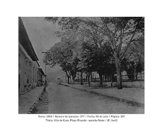
Sitios turísticos
Plaza Miranda de Villa de Cura. Es la segunda plaza de la ciudad situada hacia el este.
Madre Iglesia San Luis Rey.
- La Casa del Santo Sepulcro o Casa de Boves.
- Casa de Ezequiel Zamora.
- Casa de Rafael Bolívar Coronado.
- Gruta de la Virgen de Lourdes.
- Plaza Bolivar.
- Plaza miranda
- Biblioteca Ezequiel Zamora.
- El Museo de la Inocente Tradición Utrera.
- El calvario
- Sitio de Boca Chica.
- Sitio de la Puerta.
- Parque Samán de Las Minas o Ramón Sosa Montes de Oca.
- Hacienda El Ancón.
- Valle alto
- La guardería de juan herrera.
- Centro Hispano.
- Casa de la Cultura Rafael Bolívar Coronado.


Comments
Post a Comment